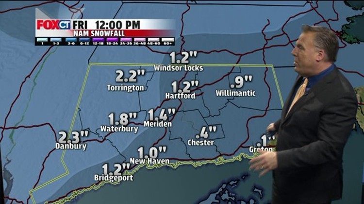
After a morning of frigid temperatures where some areas were below zero, we can expect sunshine with a gradual moderation in temperatures today. A south wind will try to usher in milder temperatures this afternoon. Clouds will begin to increase late in the day and into tonight with snow breaking out across the region after midnight. With the persistent south wind, expect temperatures to remain steady and even rise overnight. Unfortunately, the timing of the snow could make tomorrow’s rush hour a little slick as light snow will continue to fall. This cold front will spawn low pressure off-shore that will deliver a coating to 3” by late morning to Connecticut with heavier snow across northern New England. The snow will taper off mid to late morning followed by some very cold Canadian air for the weekend.
Our next chance for snow is expected Sunday night into Monday as low pressure will pass by to our south with a band of snow. However, there is a chance that the storm could completely miss us with very little or no snow at all. Either way, another Arctic surge will follow the storm with more frigid temperatures. Highs will average in the teens and 20’s, while overnight lows will average in the single digits to below 0 through next week.
Forecast Details:
Today: Mostly sunny. High: 25-32. Wind: S 5 mph.
Tonight: Thickening clouds with snow developing after midnight. Low: 25-30.
Friday: Light snow, with accumulations a coating to 3”. High: low 30’s, then falling in the afternoon.
Saturday: Sunny, blustery and very cold. High: 15-20.
Sunday: Sunshine followed by increasing clouds in the afternoon and evening. High: 20’s.
Monday: Chance for some snow. High: 20’s
Tuesday: Mostly sunny, very cold. High: teens