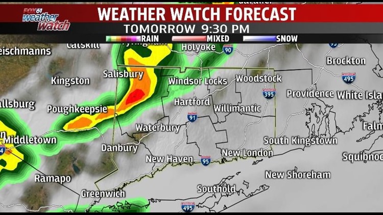
The forecast has an unsettled look to it for much of this week, although we have no real washouts on the way. The biggest concern looking forward is the threat for storms Wednesday afternoon into Wednesday evening.
Those stubborn clouds that have been with us for days now will remain in place Wednesday morning. Then clouds, fog and drizzle will break for some afternoon sunshine. The amount of sun that we get will help determine the strength of thunderstorms in the afternoon. If clouds fail to break, storms will be weaker with lightning and gusty (but not damaging) winds. But if we get some decent sun, storms could be severe. The biggest risk will be damaging winds and large hail. Storms could develop as early as 4 PM in Litchfield County. But for the rest of the state there is a bigger risk of storms after 7 PM through about midnight.
Weak high pressure builds in for Thursday bringing a break from the rain. Then another cold front will bring a round of showers later Friday into early Saturday.
Right now showers will “book-end” the weekend with rain possible early Saturday and then again late Sunday. In between, most of the time looks dry.
Forecast Details:
Wednesday: Partly sunny, chance for a late day or night storm. High: 75-80.
Thursday: Partly sunny. High: 70s.
Friday: Partly to mostly sunny. Chance for a shower/thunderstorm. High: 70s.
Saturday: Partly sunny, chance for showers. Highs in the 70s.
Check out the FOX61 Meteorologists on Facebook:
Or on Twitter: