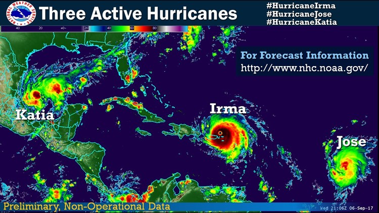
In what feels like a never-ending barrage of storms, this year’s hurricane season just passed the halfway mark — and three hurricanes, including Category 5 Irma, are churning in the Atlantic.
Storm activity usually ramps up in September — and hits its statistical peak on September 10. That’s because key environmental factors tend to align at that time to fuel especially powerful storms, according to the National Oceanic and Atmospheric Administration, which considers the eight-week period around September 10 a hurricane “season within the season.”
“There’s nothing magical about the September 10 date,” CNN meteorologist Brandon Miller said. “The peak of hurricane season really runs from the middle of August to the middle of October. But we really see the best of the conditions in early September, when the combination of ocean temperatures that have been baked by the long summer sun and the lack of wind shear that we commonly find in the late spring and early autumn leads to the greatest number of storms.”
The full hurricane season lasts from June 1 to November 30. And until two weeks ago, this season had been quite ordinary.
Then Harvey came along.
Now, Irma is hammering a string of northeast Caribbean islands and making its way toward a possible hit on Florida over the weekend. Hurricane Katia isn’t expected to have a direct US impact, and Hurricane Jose is still far out in the Atlantic — but that doesn’t mean they aren’t making people nervous.
Beyond these three, more storms could form in the coming weeks, said Phil Klotzbach, research scientist at the Department of Atmospheric Science at Colorado State University.
“You’re approaching peak of the season, and it looks like more storms are forming, so I would expect the next few weeks to be pretty active,” he said. “Hopefully, the rest of the storms will leave everyone alone. Pretty much everyone at this point is very done with hurricane season.”
Hurricane activity tends to drop off by early October, but it’s possible to get a storm in November, Klotzbach said. Only 60 hurricanes have formed in November since 1851, compared with 205 October hurricanes, NOAA reports.
The last hurricane to make landfall in November was Otto last year.
Before Harvey, the United States hadn’t been hit by a major hurricane — a Category 3 or higher — since Hurricane Wilma in 2005.
“Now we’re looking like we’re having two Category 4-5 storms in little over two weeks,” Klotzbach said. “We went from hurricanes being a non-issue to hurricanes being a daily event.”
El Niño absence helps fuel storms
Warm sea surface temperatures and a no-show El Niño were expected contribute to an above-normal hurricane season this year in the Atlantic, NOAA said last month.
El Niño is a naturally occurring phenomenon characterized by warmer-than-normal water in the eastern Pacific equatorial region. While it occurs in the Pacific, El Niño has global impact, including increased wind shear across the tropical Atlantic, which creates hostile conditions for tropical storm development.
With El Niño failing to take shape, there was a 62% chance of a major hurricane making landfall in the United States this season, Colorado State forecasters had said. The average risk is 52%.
“The wind and air patterns in the area of the tropical Atlantic and Caribbean, where many storms develop, are very conducive to an above-normal season,” Gerry Bell, lead seasonal hurricane forecaster at NOAA’s Climate Prediction Center, told CNN last month.
Climate change’s role hard to peg
The flurry of hurricanes also raises questions about whether climate change is playing a role.
But that’s hard to measure, Klotzbach said.
“If you look at storm activity over the last 50 to 60 years, there’s no trend in the Atlantic,” he said. “The Atlantic has these big broad ups and downs where you get a whole pile of storms. Trying to find climate change signals is pretty hard.”
Warmer water could be a key ingredient for a hurricane, but in these case, the water may have warmed regardless of climate change, he said.
The most direct ways climate change influences hurricane landfalls can come in the form of increased storm surge as a result of sea level rise.
‘Extremely active’ season predicted
This hurricane season isn’t on pace to be the most active year for storms.
The 2005 Atlantic hurricane season — the year of Katrina — blew away records with 28 named storms, of which 15 were hurricanes.
Although 2017 may not set a new standard, NOAA had warned that this season had the “potential to be extremely active.” So far this year, there have been five tropical storms and six hurricanes, including Irma, Jose and Katia.
NOAA in August predicted 14 to 19 named storms, five to nine hurricanes, and two to five major hurricanes for the season.
A similar outlook was issued by Colorado State University, which predicted 16 named storms for the season, including eight hurricanes and three major ones, with winds of 111 mph or stronger.