


HARTFORD — Fall has started, and soon we’ll see the trees start to change colors.
It’s always an exciting time in the state and many come from near and far to see the trees change.
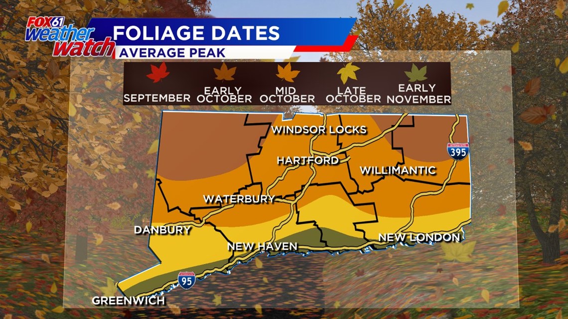
The state’s foliage map shows the Northwest and Northeast corners saw colors first, starting last week. Peak color for those areas hits the first week of October.
Most of the state is predicted to have moderate or peak color between October 16 – October 23.foliagefa
The state DEEP recommends some areas to view the leaves:
- Macedonia Brook State Park, Kent – Cobble Mountain From Kent Center, take Route 341 west for approximately 2 miles. Take first right onto Macedonia Brook Road, which takes you into the park. (Bear left at the fork.)Office and parking lot are located 1 mile inside the park. Trail maps are available. Take white blazed Cobble Mountain Trail. The overlook has views across the Harlem Valley to the Taconic and Catskill Mountains.
- Mohawk State Forest, Cornwall From Torrington, Route 4W (14 miles) to forest entrance (Toumey Road) on left. Take road to ‘T’ intersection and turn right onto Mohawk Mountain Road.Scenic vistas to the north and west include the Catskill, Taconic and Berkshire ranges. For your hiking pleasure both the Mattatuck and Mohawk trails (blue blazed) cross the site.
- Pachaug State Forest, Voluntown – Mt. Misery Overlook From Voluntown take Route 49N (6 miles) to forest entrance on the left. Go west (2 miles) and bear left at forks to parking area.Take woods access road on left to overlook.This forest also contains miles of roads and hiking trails.Peoples State Forest, Barkhamsted – Chaugnam LookoutFrom junction of Routes 318 and 181 in Pleasant Valley, go east over bridge then take first left onto East River Road. Jesse Gerard trailhead is 2.4 miles on the right. Recreation area is opposite the trailhead.Take trail (yellow blazes) to two lookouts.
- Shenipsit State Forest, Somers – Observation Tower(Please Note: Observation Tower closed until further notice.) From Somers, Take Route 190E (1.25 miles) to blinking yellow light. Turn right onto Gulf Road (2.25 miles) to next right after Mountain View Road, which is Soapstone Mountain Road. Take road to tower parking lot.For your hiking enjoyment, Shenipsit Trail (blue blazed) runs by the tower. The observation tower on Soapston Mountain provides wonderful views of the surrounding and distant landscapes. PLEASE NOTE: Observation Tower closed until further notice.
- Talcott Mountain State Park, Simsbury – Heublein Tower
From Bloomfield, take Route 185W (3 miles) to entrance sign on left after mountain crest.
Park along the road near the trailhead. Hike to ridge, then left to the restored Heublein tower. View from tower is over the Farmington River Valley.Another nearby alternative is located at Penwood State Park (entrance is on left 500 feet east from Talcott Mountain entrance). From the parking lot, a hike up the gated road loops to an escarpment overlook.Mt. Tom State Park, LitchfieldLocated off Route 202 – A stone tower 1, 325 feet above sea level can be reached by hiking a one-mile long trail. - Dennis Hill State Park, NorfolkLocated off Route 272 – A summit pavilion located 1, 627 feet above sea level provides views of New Hampshire, Vermont’s Green Mountains, and more.The drive to the summit is open weekends only from October 4 through October 26.
- Goodwin Conservation Center, On Route 6 in Hampton
View autumn colors reflected in the water of Pine Acres Pond from the wildlife-watching platform (wheelchair accessible). You can also walk through the canopy along one section of the Air Line Trail in the Goodwin State Forest.