Scientists who visited one of the world’s newest and most unique islands last year discovered a mysterious, sticky mud, said NASA.
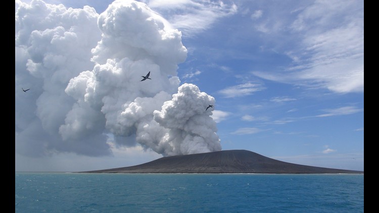
The island is located in the South Pacific near Tonga and is unofficially called Hunga Tonga-Hunga Ha’apai (Hunga Tonga). It came into being after a volcanic eruption in late December 2014 connected two older islands. NASA says it is the first island of its kind formed since satellites began consistently taking pictures of Earth.
Scientists initially predicted it would be around for just a few months. But a NASA study released in 2017 found that the island survived “against all odds” and could last from six to 30 years.
Scientists have been mapping Hunga Tonga closely since its formation using aerial and satellite surveys, but it wasn’t until a team traveled to the island by boat in October last year that researchers became aware of its unique vegetation.
“We were all like giddy school children,” said Dan Slayback of NASA’s Goddard Space Flight Center in a post on NASA’s Earth Expedition blog on January 30 detailing the research trip.
“Most of it is this black gravel, I won’t call it sand — pea sized gravel — and we’re mostly wearing sandals so it’s pretty painful because it gets under your foot.”
Slayback said the “light-colored clay mud” was one of the most intriguing surprises he found on the island.
“It’s very sticky. So even though we’d seen it we didn’t really know what it was, and I’m still a little baffled of where it’s coming from. Because it’s not ash,” Slayback said.
Slayback was also surprised that vegetation was beginning to grow on an isthmus on Hunga Tonga-Hunga Ha’apai.
NASA said the vegetation was likely fertilized by bird droppings. The animals were likely living on the older nearby islands, which have plenty of plant life.
Researchers used a high-precision GPS unit and a drone to create a higher-resolution 3D map of the island.
“It really surprised me how valuable it was to be there in person for some of this. It just really makes it obvious to you what is going on with the landscape,” he said.
Slayback said that the island appears to be eroding quicker than previously thought due to rainfall.
“The island is eroding by rainfall much more quickly than I’d imagined,” he said.
“We were focused on the erosion on the south coast where the waves are crashing down, which is going on. It’s just that the whole island is going down, too.”