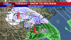
Tuesday’s storm is a winter of 2018-2019 special! Snow changing to ice and rain situation. Sound familiar? This winter we still can’t seem to manage an actual snow storm. You know, storms where *just* snow falls from the sky?

The set-up:
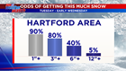
A strong storm will slide through the Great Lakes on Tuesday, passing its energy off to a coastal low near the Delmarva Tuesday night. Initially we feel confident this storm starts off as snow with plenty of available cold air to start. Then the transfer of energy will allow for a change in precipitation types. But before the change-over occurs, we have the chance to see some heavy snowfall rates, allowing snow to add up quickly during the day Tuesday. Ultimately, the final track of the coastal low and how fast it deepens will determine the timing of the changeover and precipitation types.
Timing:
Starts after the morning commute Tuesday. Accumulating snow is likely before the changeover to sleet/freezing rain in the afternoon. A changeover to rain is possible as well, especially along the shoreline/southeast Connecticut. Precipitation ends early Wednesday morning.
Impacts:
– No matter how much snow/ice/rain we get this will affect travel.
– If there is a freezing rain component, outages are possible. But there may be more sleet than freezing rain in this set-up which would help.
– School changes (dismissals, closings possible Tuesday, delays possible Wednesday)