A bomb cyclone is taking shape along the Eastern Seaboard and starting to make itself felt in the Northeast.
Rain is falling across the region and winds are picking up speed and are forecast to last through Friday. The National Weather Service has issued a flash flood watch for about 7 million in the Northeast and a wind advisory for more than 60 million in 14 states stretching from the Appalachians in North Carolina all the way through Maine.
Generally, a bomb cyclone is defined by a pressure drop of 24 millibars (a unit of pressure) within 24 hours. The pressure of the system could drop more than 30 millibars in 24 hours — making this a bomb cyclone, the National Weather Service in Boston said Wednesday.
“The system will have the equivalent low pressure of a Category 1 hurricane,” said CNN meteorologist Dave Hennen.
One to two inches of rain fell in the Mid-Atlantic states Wednesday, but the heaviest rains will be Wednesday night and Thursday in the Northeast. Up to three inches is expected for much of the Northeast, with isolated areas receiving up to 6 inches through Thursday, according to the National Weather Service.
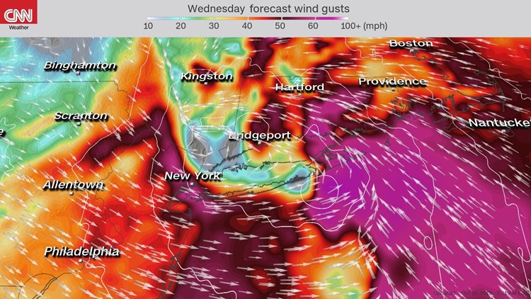
Winds could reach tropical-storm force (39 mph+) with even higher gusts by Wednesday and Thursday for places such as New York City, Boston and Portland, Maine.
Expect numerous flight delays and cancellations in New England Thursday and Friday, as the strong winds hold on until Friday evening before diminishing.
Wind is cited already for delays at Newark International Airport, which is currently experiencing delays averaging 2 hours and 26 minutes, according to the Federal Aviation Administration. Traffic arriving at La Guardia Airport in New York is currently delayed 50 minutes.
Some areas could top out with winds reaching more than 60 mph. With most trees still holding on to their leaves, these winds could have an easier time bringing down trees and power lines, potentially cutting power to thousands of people.
The rain will taper off throughout the day on Thursday, then completely lift out of northern New England by Friday.
Not a classic nor’easter but still strong
Although it is not likely the storm will meet the criterion of a classic nor’easter, it will be just as strong as the storm that impacted the mid-Atlantic and Northeast last week, if not a little stronger.
Models are showing it will likely stay more onshore compared to the coastal storm last Friday.
A cold front will lower temperatures with the eastern half of the country 5 to 20 degrees below average for high temperatures on Thursday. The storm will not be a major snow-maker for most of the region, except for a small portion of upstate New York.
This is the second coastal storm to impact New England in a week. Last week’s storm sat off the coast of the mid-Atlantic, churning up seas and bringing a strong onshore wind that shredded beaches up and down the East Coast. It caused costly damage along the coast due to beach erosion and coastal flooding.