
HARTFORD, Conn — It's been a strange few months of weather in southern New England.
The heat came on early and strong in the month of April, when the Hartford area hit 96 degrees on the 14th. That broke the record for the day, but it also tied the record warmest day in the entire month of April.
Records for the Hartford area are kept at Bradley International Airport in Windsor Locks, and date back to 1905.
We then experienced a frost and freeze in May, when temperatures dropped to near or below freezing on the 18th. The accelerated plant growth due to April's warmth faced a setback with such a late freeze.
June was one of the cloudiest in recent memory, but we didn't experience much heavy rain. We also dealt with days of wildfire smoke in our sky and in the air we breathe. Rainfall for the month was actually 3 inches below average in the Hartford area. Although we didn't have much to show for it, rain fell on 19 of the 30 days, and the weather pattern appeared ripe for more widespread heavy rain at some point.
We cashed in on that over the last four weeks. And then some.

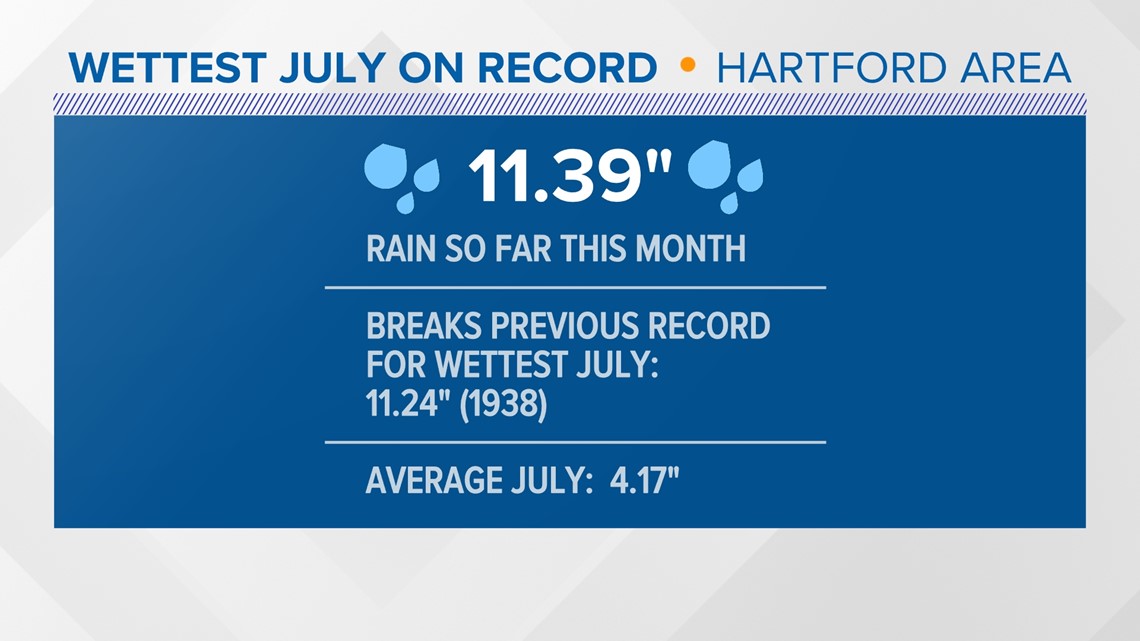
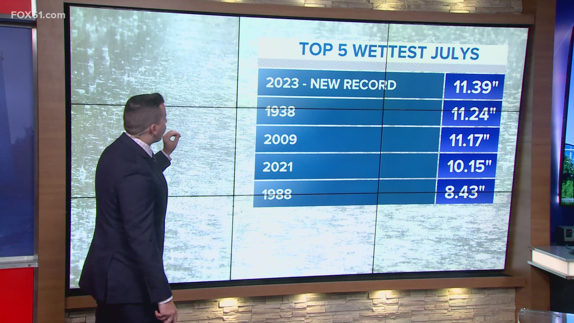
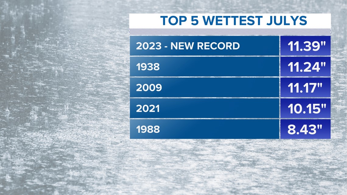
A series of slow-moving downpours and thunderstorms have dropped more than 11 inches of rain in the Hartford area so far this month. The average July rainfall is 4.17 inches.
By the end of Friday the 21st, 11.39 inches of rain had fallen at Bradley.
This broke the previous record for wettest July, 11.24 inches, set back in 1938. Later that year, New England was hit by the Hurricane of 1938, which felled trees due to the saturated soil.
And the record was broken with 10 days still to go in the month.

Is this connected to climate change?
It's a loaded question, but worth considering.
A warmer world can hold more moisture. A rise of one degree Fahrenheit equals as much as a 4% increase in atmospheric water vapor. Our summers are unquestionably trending warmer and more humid. So, the potential for heavier rainfall events is increasing, and that's one of the clearer signals of our changing climate.
Recent summers have featured big swings though. Last summer it was a drought. This summer it's been too much rain. Just two years ago, 2021, also ranks on the list of wettest Julys. That summer was a bit different than this one; we were hit by a few tropical systems, which accounted for much of the rainfall. The summer before that we faced another drought.
It could be coincidental we have experienced these back-to-back extremes recently, but some studies that suggest extremes on either end of the spectrum are intensifying too.
Ryan Breton is a meteorologist at FOX61 News. He can be reached at rbreton@fox61.com. Follow him on Facebook, Twitter and Instagram.
Have a story idea or something on your mind you want to share? We want to hear from you! Email us at newstips@fox61.com
HERE ARE MORE WAYS TO GET FOX61 NEWS
Download the FOX61 News APP
iTunes: Click here to download
Google Play: Click here to download
Stream Live on ROKU: Add the channel from the ROKU store or by searching FOX61.
Steam Live on FIRE TV: Search ‘FOX61’ and click ‘Get’ to download.